Physical Details
- Type
- textile
- Material
- woven reed, dyed river grass, hammered copper markers
- Era
- 3050 BCE
- Condition
- Fragmentary
- Dimensions
- 55cm H × 38cm W × 0.4cm D
- Weight
- 120g
- Catalog #
- APO-2026-00013
rareAPO-2026-00013
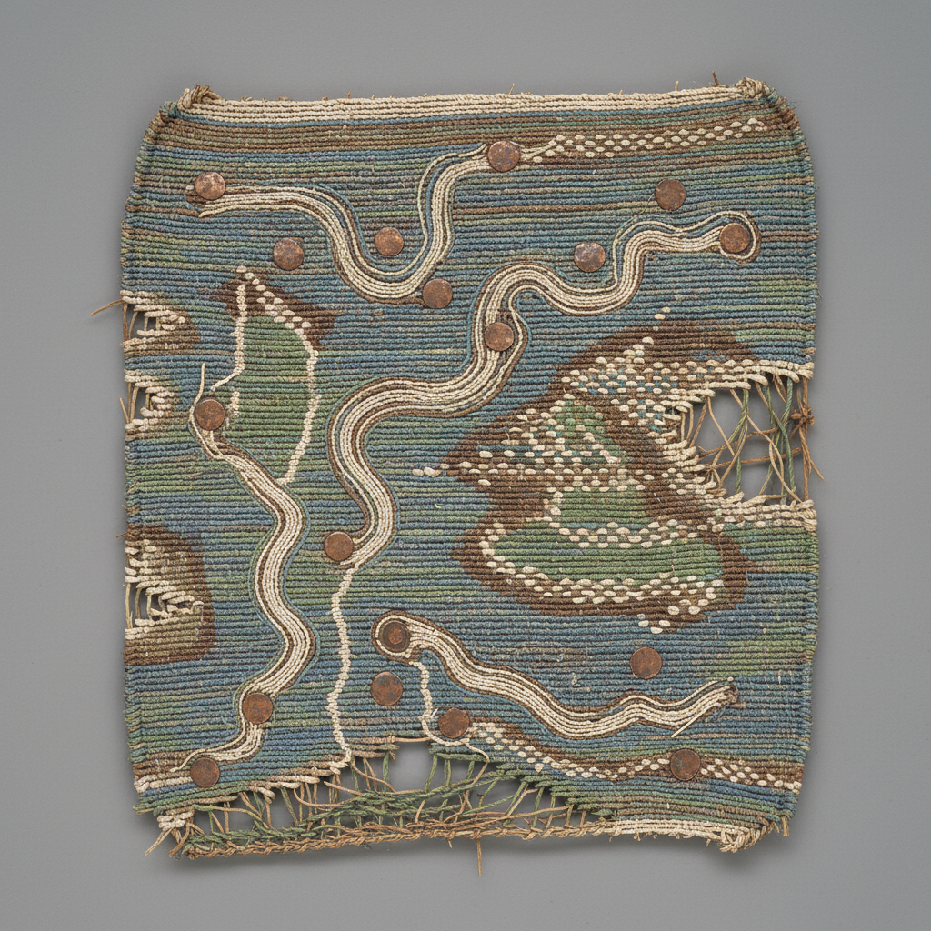
Reed-Woven River Navigation Chart
Before maps were drawn, they were woven. This reed chart guided Vorrashi river pilots through the basin's complex waterways — a navigational tool made from the same material as the boats it guided. The copper markers are the earliest known use of metal for cartographic notation.
Ritual Inscription (Oral Tradition)
Va ve ha-si we ne he va vai mu ra ko so la lo ve
/va ve ha.si we ne he va vai mu ɾa ko so la lo ve/
Translation
“The river flows toward the sky, yet one cannot know the deep water — the source-people remember the story by which the boat moves.”
Interlinear Analysis(click to expand)
| Form | Gloss | POS |
|---|---|---|
| Va | water/river | noun |
| ve | flow/go | verb |
| ha-si | sky-toward/descend-seeking | verb-compound |
| we | but/however | conjunction |
| ne | NEG | particle |
| he | see/know/understand | verb |
| va | water/river | noun |
| vai | deep/profound | adjective |
| mu | mother/source/origin | noun |
| ra | people/kin | noun |
| ko | sing/tell/remember | verb |
| so | song/story/oral-tradition | noun |
| la | REL | particle |
| lo | boat/vessel/reed-craft | noun |
| ve | flow/go/move | verb |
Script: not applicable — oral tradition only; this textile inscription represents navigational pattern-weaving, not a true writing system
Description
A flat panel of tightly woven reeds with dyed grass fibers creating a schematic representation of the three rivers — Keth, Voral, and Ashenmere. Small hammered copper discs are knotted into the weave at specific intersections, marking what scholars believe are safe mooring points, portage sites, and seasonal fishing grounds. The central confluence is marked with a larger copper disc bearing the double-wave motif. Approximately 60% of the original chart survives.
Scholarly Analysis(click to expand)
The chart represents the oldest known cartographic artifact in the Ashenmere Basin, predating Kethari clay maps by 800 years. Dr. Tanaka-Reeves used the copper marker positions to reconstruct Vorrashi trade routes, confirming that river commerce was far more organized than previously assumed. The dye analysis reveals three distinct pigment sources: indigo from highland plants, ochre from riverbank deposits, and a green copper-carbonate wash. The weaving technique is consistent with Vorrashi double-hull boat construction.
Provenance(click to expand)
- discoverer
- Dr. Yuki Tanaka-Reeves
- discovery date
- 2022-03-15
- condition notes
- Upper-right quadrant missing. Reed fibers fragile — stabilized with conservation resin. Two copper markers detached but recovered in situ. Stored in climate-controlled nitrogen case.
- excavation team
- Pacific Institute Field Survey
- discovery location
- Submerged cairn burial, Voral tributary junction, Site 9